Water intelligence.
Without the Complexity.
SI-Ai brings together live sensor data, weather patterns, and local infrastructure into a single operational picture so communities can understand what’s happening, anticipate what’s coming, and act before it’s to late.
Deployed in Galveston County, April 2026
From Fragmented Data to Actionable Intelligence
Some communities need Simplicity Integration for a complete solution and we build fast deploying sensor networks that can provide insights from day one of deployment. But other communities already have sensors, weather data, and infrastructure in place. Their challenge is that the pieces aren’t connected in a way that supports real-time decisions. SI-Ai is the integration layer that changes that.
“The challenge isn’t that we lack technology, it’s that the systems don’t work together. We pull all the data together so communities can finally understand what’s happening in real time.” Alison Reese, COO & Co-founder, Simplicity Integration
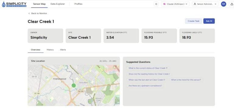
Powered by Axonis Decision Intelligence, SI-Ai ingests live sensor readings, public weather and water level data, historical trends, and local infrastructure data into a single map-based dashboard giving operators and residents a clear, real-time view of changing conditions.
How It works
From Monitoring to Predictive Action
SI-Ai doesn’t just collect data, it connects it, analyzes it, and turns it into decisions communities can act on immediately.
01
CONNECT
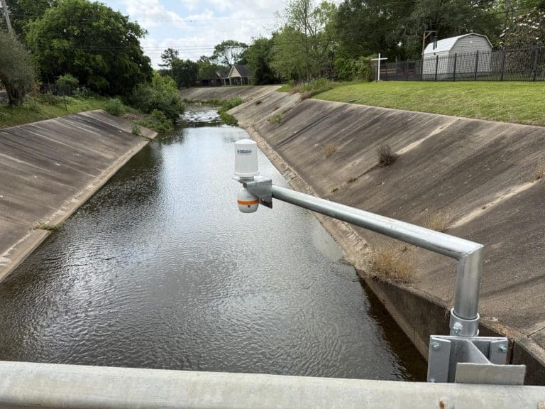
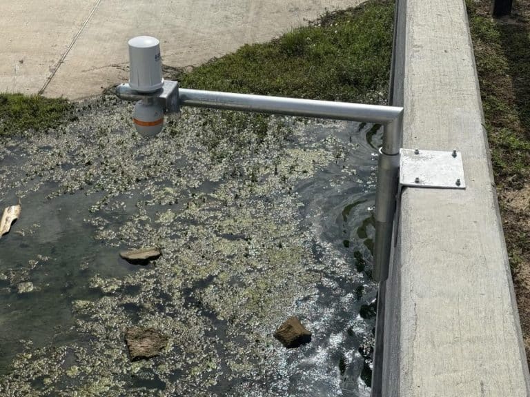
Rapidly deployed sensors attach to bridges and waterway infrastructure in hours, no trenching, no fiber. SI-Ai also ingests public stream and waterway data, weather station feeds, and can bring in existing customer systems to build a complete local picture for the specific water challenge our customers face.
02
ANALYZE
The platform correlates water level data with upstream readings, rainfall totals, terrain type, and historical patterns. Our decision intelligence tool identifies trends and flags anomalies such as locations that trigger “potential flooding” too frequently, signaling a threshold needs review or a location where sensors aren’t reporting frequently enough to provide for adequate flood preparedness.
03
PREDICT
Over time, the system learns how water behaves in each unique geography. With a forecast of four inches of rain, SI-Ai can provide customers with insight into things like water rise rates at specific locations so they can better prepare for when conditions become dangerous.
04
ALERT
Residents sign up for hyper-local text alerts tied to specific crossings or waterways they care about. Text alerts fire automatically at thresholds set by local engineers and clear automatically when conditions normalize. No generic county-wide warnings so people can understand what is happening in real-time.
05
AUTOMATE
When thresholds are crossed, SI-Ai can trigger infrastructure automatically: warning lights activate, gates close, sirens sound. Built-in redundancy (cellular + satellite, solar + battery) ensures the system performs when it matters most. If your community already has some infrastructure built, Simplicity will integrate that information and can help automate safety equipment using what is already in place.
06
PRIORITIZE
Historic and real-time data together show where flooding originates and how it moves downstream giving communities the evidence they need to invest limited infrastructure dollars where they’ll make the greatest difference.
Platform Capabilities
Everything You Need to Understand Your Water
SI-Ai is built to adapt to your community’s specific challenges whether you’re monitoring hundreds of miles of waterways or a handful of critical low-water crossings.
🗺️
Live Map Dashboard
Color-coded map view (green > yellow > red) let’s anyone understand conditions at a glance. There is no technical expertise required. Click any pin for real-time readings and historical data at that location.
📡
Multi-Source Data Ingestion
Combine your own sensors with public datasets, weather stations, upstream monitoris, and third-party systems into one unified view. Customers don’t need to own hardware to start gaining insight. The system can even help inform as to vulnerable locations that need visibility.
🔔
Hyper-Local Resident Alerts
Residents opt in to text alerts tied to specific locations they care about. Location-specific alerts reduce alert fatigue and drive real behavior change where generic county warnings do not.

AI-Powered Predictive Decision Intelligence
Axonis Decision Intelligence correlates rainfall forecasts, upstream water movement, terrain type, and historical patterns to anticipate flood events and vulnerable locations before they become emergencies.
⚡
Automated Infrastructure Control
Thresholds trigger automated responses such as warning lights, gate closures, sirens, and barriers so communities don’t rely on someone manually making a life-safety decision in the middle of a storm.
🔒
Defense-Grade Security
Build on Axonis’s federated, zero-trust architecture, which is the same foundation used by the Department of Defense, your data stays where it lives which means AI analysis comes to the data, not the reverse.
In the Field
Galveston County Deployment
Simplicity Integration’s Galveston area deployment includes monitoring waterways serving dense residential neighborhoods. In April 2026, Simplicity deployed multiple sensors in a single day across locations identified by the county’s drainage district engineers.
1 Day
Multi-Site Installation
Day 1
Multi-Site Installation
Custom
Thresholds per location
Real-Time Information
Customer webpage for location specific map and alert sign-up
Residents can now sign up at a county-specific webpage to receive text alerts tied to crossings and channels in their neighborhood. County engineers set location-specific flood thresholds because what triggers flooding in a shallow channel behaves differently than a deep waterway a mile away.
The deployment is already generating predictive insights. The system tracks how quickly water moves from upstream sensors to downstream locations and correlates rise rates with incoming rainfall forecasts.
Good Data Creates Practical Action.
See how SI-Ai can help your community understand its water, anticipate risk, and act with confidence starting from day one.
To learn more about how Axonis and Simplicity Integration are working together, watch the Q&A session below.